 We have started a new section of fire news for Saturday, Aug. 29. Thanks to all who contributed photos, stories, email, and comments yesterday. We pulled through it, but as we sit at 7 AM and hear the aircraft rumble, we know there's another full day ahead. Pray for the firefighters!
Again, key sites:
Inciweb for Station FireLaCanadaFlintridge.Com for news from that city.
CAVEAT: We're staying here at HQ rather than going in the field, as (1) we have two kids to take care of solo, and (2) we can give you information faster here if we huddle in front of the computer and scanner. We WILL be off-line mid-late PM so we can see our wife in the hospital -- will be back in the early evening.
--------------
THE LATEST
 11:30 PM: Crown City Who? Wrapping this up for the day -- just watched Crown City News on internet feed for Ch. 56, and they said for information on the fire, go to the Pasadena city website or LaCanadaFlintridge.com. We, apparently, are chopped liver.
And remember earlier today when we said we'd just passed 160,00 page views? That was then, this is now -- we're at 172,000 page views. Yup -- 12,000 today. Thank you all! That's a lot of liver.
Stats: the fire tripled in size today, about 20,000 acres. Local evacuated areas include north of Loma Alta from Lake to Lincoln, the Meadows and La Vina areas, and the Florecita neighborhood in northwest Pasadena. There is an evacuation area, but not a shelter, at Jackson Elementary, but our reports from the ground aren't too impressed with it.
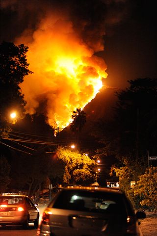
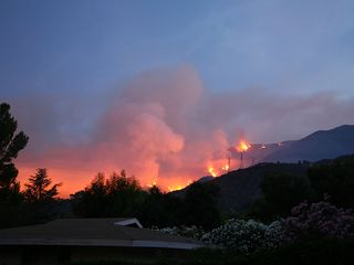
The photo was sent by Bethany Baird, of the Poppyfield/Olive area, taken tonight. (Thank you!)
We echo the sentiments of Lynn Marini, who wrote:
Hi, I'm Lynn Marini & I actually live in Pasadena but my family lives in Altadena & I worship @ St. Mark's.PLEASE express my gratitude to everyone who is working so diligently to keep us posted with up to minute & accurate reports. God Bless you & keep you safe. We are praying for the safety of all the firefighters & law enforcement persons.Gratefully,LynnIndeed. Let's hope for a peaceful night, and that we all stay safe.
10:30 PM: At least the critters are safe: Greg Sweet sent this over in the afternoon when we were gone, and we're just catching up to it now:
I just spoke with Sue Burgess at the pack station at Chantry Flat. Sierra Madre Search & Rescue has told them that the fire has round Mt. Disappointment and is advancing on Mt Wilson. S&R told the pack station that if the fire continues as is, they have about twelve hours to evacuate. That would be 3am. So I checked with the folks at Alta Loma Equestrian Center and they told me "go ahead and bring them." I said, "It's 12 donkey and one mule!" and they said "It's an emergency! Don't worry about it!"
The six goats may come to my house.
Steve's Pet's offers shelter: Carrie Meyers, owner of Steve's Pets, tells us:
Steve's Pets at 2395 N. Lake Ave in Altadena is offering a safe place to board your animals free of charge for anyone that has been evacuated from there homes. We are open Saturday and Sunday from 10am to 5pm 626 798-6290 if its after 5pm please call 375-6446.
God Bless
Whisky Tango Foxtrot moment: Phone rang this afternoon: "Hi, I was planning to move to
Altadena, and I wondered if I could spend a few moments getting information from you -- like when the trash collection day is, what the neighborhoods are like ...." We said we were too busy.
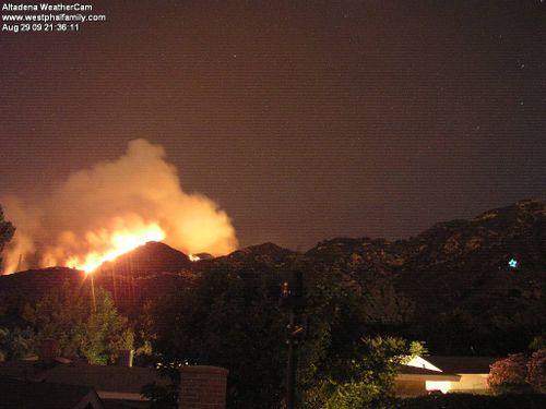
9:30 PM: Bill Westphal, who is remaining in his Hollyslope Road home despite an evac order, gives us a ray of hope on his Weathercam:
This sounds a little corney but the Star Of Palawoo is lit tonitght giving us a little hope in all this. (Star is on far right)
Nice to be wanted: Mindy Lemoine emails us: "Our house on Monterosa Dr was mandatorily evacuated around 4:30. We are hightailing it back from Vegas and hanging on your every update by iPhone!!!!"
Pictures: thank you all for the pictures you're sending! We're still busy catching up with written data -- but we're already thinking of putting together a "Fire of 2009" page after this is all over, and we'll use a lot of them! Nice to have so many journalists on the ground here in Altadena!
8 PM: How to help: Lonnee Hamilton writes us that she's started a blog at her Rose City Obamaworks site to share information about what is needed and how to help:
http://rosecityobamaworks.ning.com/forum/topics/la-canada-altadena-fires-how
Evac, evac, where's the evac? Last we heard this afternoon (before we went on our hospital visit), Muir HS was the place for evacuees. Apparently during the afternoon it was changed to Jackson Elementary. Lonnee, in a later email to us, says that only about four people were at Jackson and they may move to La Canada-Flintridge High School, another evac center. We WILL try to pin down where evacuees are to go!
7:50 PM: Fire moving north: Gino Sund writes@ 7:45 PM:
Update on fire: latest flyover with visual and infrared analysis by County Fire indicates that the fire is moving away from Altadena but still in direction of Mt. Wilson. No structures burned and danger to residences seems to lessening.
7:45 PM: Chaney Trail neighborhood preparing for evac: Alice Wessen sent this to the Chaney Trail group:
I just recieved a map with all of our addresses on it. The last person here is going to give it to the Structure Protection Commander (what a title) before they leave.
What will happen is you will start to see increased presence of emergency vehicles, USFS, Fire trucks on our roads (Alzada, Chaney, Jaxine) setting up and sheriffs will be here to alert us with very loud speakers. Fire they give a voluntary evac order then it is a mandatory....of course it depends on winds etc. It may go straight to mandatory. Just don't know yet.
It will not be any subtle like a phone call or reverse 911 or such. It will be very loud speakers and sheriffs hollering out to get out. They will want to coordinate our evacuation along with the increased presence of vehicles to each doesn't impede the other.
I think most of us have our cars already turned around and are packed.
Take care
Prepare for power outage: Gino Sund writes: "Just a thought about being prepared. There currently is a new power outage in La Canada due to the fire. The major transmission lines to Altadena could also be affected by this fire. I don't want to be an alarmist, but we know that a power outage is a possibility for Altadena. Being aware of this possibility, might allow you to be better prepared in case this becomes a reality."
He also writes (we're still chewing through emails!): "Just got the word that County Fire will be evacuating all homes north of Loma Alta, from Canyon Crest (Lincoln) to Lake Ave. Beginning in the West working toward Lake. This will take several hours."
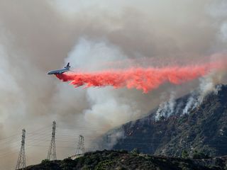
7:30 PM: Bill Westphal, who contributed this photo of a DC-10 fire retardant drop above, tells us that his Hollyslope Road neighborhood has been ordered to be evacuated, but he and several other neighbors intend to stay to help firefighters and forestall looters. Godspeed!
Chris Considine writes (at 7:12 PM):
I just spent an hour roaming the westside of Altadena. I was at the Winslow turnout above JPL along with a lot of people and 3 news crews. This viewpoint is probably best for seeing the advancing fire that is attacking the Millard Canyon area and the Cheney Trail fire break. Several P-3's were hitting the fire with retardant, and as predicted the DC-10 came back from the first hit in one hour from the round trip to the high desert airport refilling station and back. As is the standard procedure, it made two scouting runs with the lead plane and then on the third run hit exactly on the high point fire break. Photos show this. Literally minutes later the fire exploded into extremely high flames, Photo shows this, and the retardant drop was RIGHT ON THE MONEY to prevent an explosive run over the break. I can't say that is totally stopped it, but it couldn't have been a better call by the forestry department.
Traffic is getting out of control up there....best that everyone STAY home in their current positions. At least 8 CHP officers along with many other law enforcement people are trying to keep people away. So stay home. We NEED them to be able to EVACUATE people if necessary, and not just stop lookie loos.
I am devastated to think that my favorite haunt of Millard Canyon and Brown Mountain road are gone, but it looks that way.
Scanner geeks alert: Steve Rhoades writes:
A lot of fire freqs are active this afternoon. Some of the more interesting ones I am hearingare:
- Fixed wing air to air: 169.2875 (I didn't have this one in my list previously, does it have an official designation?)
- Air Attack 134.675 AM Most of the fire fighting helos are here.
- "Air coordinator" - 122.920 AM. Not sure of the official designation, but mostly reports for other units.
- LASO CTAC-2 482.8375 Command Post. Evacuation orders can be heard here.
- LACOFD Blue-5 470.6625 Structure Protection. Reports of endangered property and early discussion of evacuations.
7 PM: Just got home and are catching up as rapidly as we can! Did notice that the Fair Oaks/Loma Alta/Wapello intersection is closed down, so don't go anywhere near it right now -- we were caught in traffic for about 20 mins. trying to clear it.
Also, at about 6 PM, John Muir HS didn't look like it was receiving visitors.
We also recommend reading the comments section for valuable info.
NORTH OF LOMA ALTA EVACUATION: From Ann Meister:
Around 4:30-5 pm. Are you aware that the police announced a mandatory evacuation to those of us living north of Loma Alta between Lake and Fair Oaks. They were even making the horse people walk in and walk out their horses.
Mt. Wilson: Observatory reports that staff has left the area, and fire may reach the observatory Sunday. A superscooper is flying in from Ontario, Canada, to help defend the observatory and antenna field, loss of which would be devastating to Southern California communications.
Sharon McNary of KPCC writes: "KPCC's newsroom is interested in hearing from
people in the fire-threatened areas, whether they are still at home, or
evacuated. People can share their stories and upload photos using this
link: www.scpr.org/in/questions/
Replies are confidential, nothing you share is
aired or published without permission. A reporter or producer might
call for more information."
UPDATE 1:30: Mt. WIlson: Apparently now there is growing concern that the critical communications towers on Mt. Wilson may be endangered. In a note to the "neighbors" usegroup, Steve Bass reports that there is only one engineer now on the hill taking care of all stations. Upper Big Tujunga Rd. is no longer usable for egress due to a fire 300 yards from Colby Ranch on Upper Big Tujunga. The only safe way out now is through Wrightwood.
Update 12:25: Dimitri just sent this first-hand report, which we've moved up from comments:I just got done with an extensive driving tour of Altadena, La Canada, and La Crescenta. Lincoln is closed at Loma Alta, except to residents. La Vina does not appear to be in any immediate danger. The fire is around a mile from JPL, but the more intense burning seems to be to the east and west of there and also further up the canyon. Cheney Trail is not closed, at least not at Loma Alta, and the fire is burning fairly far up the mountain from there.
The homes most threatened seem to be those few at the very top of The Meadows. The flames are fairly close to those homes now. Also, the homes near the La Canada Country Club are still threatened, but not as directly from my point of view, but I had a hard time seeing back behind the lower ridges. I base this comment on the relative lack of smoke and flames emanating from that area. The fire is raging up the side of the mountain to the east, but up and away from homes. The wind has picked up, but is blowing the fire back onto previously-burned areas, which may be a good thing.
I was a little disheartened by the lack of heliocopters and planes battling the fire. There were only two helicopters making sporadic drops and those were on the La Canada side. It seems a lot more resources were expended on the Sierra Madre fire last year, with the planes making constant chemical drops. I agree with those who claim that the fire department strategy seems to be to let it consume fuel and burn itself out, but that is, literally, playing with fire when the flames are so close to residential areas. I was very surprised to not see constant drops on the ridge behind The Meadows given the proximity of intense and open flames to some of the homes there. I may be reading too much into this, but I got the perception that the fire crews were working harder to save La Canada, possibly because there are many more houses on that side of the Arroyo.
The Bullet at Noon: Area north of Canyon Crest and West of Lincoln received mandatory evacuaton orders -- includes Meadows and La Vina. Evac center set up at John Muir HS, 1905 Lincoln Ave., Pasadena. Air assets are on their way. The fire has consumed over 7.500 acres. Scanner just called for VOLUNTARY evacuation of Sunset Ridge east of Lincoln.
UPDATE 12 NOON: "Air assets" (i.e. fixed wing aircraft for sure, maybe choppers to follow) are on their way to assist. Ocean View Blvd. on the La Crescenta end of the fire is due for a water drop soon, as flames are 100 yds. from houses there.
Reader Sam Nemati says that a firetruck as just stationed itself on the top of Crestford Dr. He also contributes this photo, taken about 15 minutes ago:
UPDATE 10:46: John Muir was just confirmed as evacuation site.
UPDATE 10:15: Scanner just announced that evac site is John Muir HS on Lincoln. Will try to get this resolved! (10:20: Sheriff's station doesn't know where evac is going to be!) Our bet is Muir as it's farther from the fire zone.
UPDATE 10:08: Loma Alta Park is evacuation center site.
UPDATE 10:03 AM: Scanner said they are now to start evacuating west of Lincoln and N. of Canyon Crest Rd. Fire and sheriff's units are being deployed to assist. Meadows & La Vina and points surrounding.
UPDATE 10 AM: Sheriff's station tell us that they're thinking of mandatory evacs, but haven't made it official yet -- whereas one of our readers there says they ARE evacuating Meadows and La Vina.
UPDATE 9:30: Police scanner chatter says fire units are at the top of Risinghill Rd., and looking for approval of a fire chief to begin evacuation. Nothing official yet, but stay tuned. If you're on the scene, let us know!
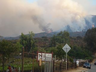 Leslie Lowes took this picture this morning by Nuccio's Nursery on Chaney Trail.
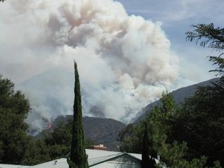
UPDATE 7:30 AM: Weather guy Bill Westphal contributes: "A view from our back yard this morning looking North-Northwest. As of 6am, temperature 74°, 13% Humidity and slight wind from the Northeast."
 Greg Sweet contributes this Forest Service map of the closed areas:
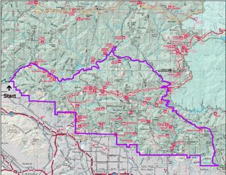 Greg also contributes a letter from Bear Canyon Forest Volunteer Richard Nyerges, in the comments section.

