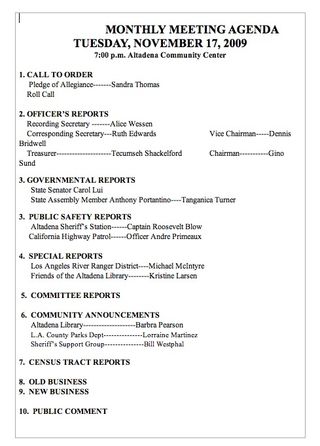
... at the Community Center, 730 E. Altadena Dr.

We have heard (unofficially at this time) that the closed meeting to consider recommendations of the investigation committee will be moved to next month -- so this may be an uneventful meeting after all. But one never knows.
(UPDATE 5/16: Due to red flag warnings, Mike McIntyre will not be available, and the presentation detailed below has been moved to December)
Alice Wessen tells us that Mike Mcintyre of the US Forest Service will do a presentation on the burned areas (BAER) report:
I posted the full USFS report, burn maps and several reports on debris
flow, botany assessment, geological and hazard assessments to my
website here (too large to send).
http://www.alicewessen.com/
From Mike McIntyre, USFS: .... "The area above the Chaney Trail Gate
is a mix. We have basically closed the burned area till at least after
winter for health and safety but the area east of Chaney Trail is open
but Millard Campground and Millard Campground and Mt. Lowe Truck Trail
and Sunset Ridge is closed.
So you can walk on Chaney Road up to the Forest Boundary but everything
west and north in the Forest is closed except to those with permits
(like the Cabin owners). We are trying to see what is workable"
----
The USFS Burned Area Emergency Response (BAER) program
Summary of Baer Report: While many wildfires cause little damage to the
land and pose few threats to fish, wildlife and people downstream, some
fires create situations that require special efforts to prevent further
problems after the fire. Loss of vegetation exposes soil to erosion;
runoff may increase and cause flooding, sediments may move downstream
and damage houses or fill reservoirs, and put endangered species and
community water supplies at risk. The Forest Service Burned Area
Emergency Response (BAER) program addresses these situations with the
goal of protecting life, property, water quality, and deteriorated
ecosystems from further damage after the fire is out.


