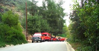
We're keeping this at the top of the page today.
UPDATE 3 PM: Well, after a white-knuckle drive to pick our son up from school in Sierra Madre (facing floods, thunder, and hail along the way), we're back ...
Via Alice Wesson, a real-time webcam of the Arroyo Seco flow:
http://ca.water.usgs.gov/webcams/jpl/webcam-oper.html
and National Weather service says were are now in flash flood warning mode:
...A FLASH FLOOD WARNING REMAINS IN EFFECT UNTIL 500 PM PST FOR THE STATION...MORRIS...AND SANTA ANITA BURN AREAS IN CENTRAL LOS ANGELES COUNTY...
AT 205 PM PST...DOPPLER RADAR INDICATED A LINE OF INTENSIFYING THUNDERSTORM ACTIVITY EXTENDING FROM DOWNTOWN LOS ANGELES NORTHEASTWARD INTO THE MORRIS BURN AREA. THIS LINE OF INTENSE STORMS WAS MOVING SLOWLY NORTHEAST...AND WILL LIKELY IMPACT THE STATION BURN AREA BY 230 PM. VERY INTENSE RAINFALL RATES HAVE BEEN OBSERVED NEAR THE MORRIS BURN AREA...WITH SAN GABRIEL DAM REPORTING .48 INCHES IN 15 MINUTES. THE HEAVY RAINFALL RATES WILL LIKELY GENERATE FLASH FLOODING AND DEBRIS FLOWS IN THE BURN AREAS THROUGH 5 PM.
PRECAUTIONARY/PREPAREDNESS ACTIONS...
RESIDENTS AND MOTORISTS IN AND BELOW RECENTLY BURNED AREAS SHOULD BE ALERT TO FLASH FLOODING AND DEBRIS FLOWS WHICH MAY BLOCK ROADS AND CULVERTS.
UPDATE 1:30 PM: CERT Volunteers requested to be on standby: From the sheriff's station:
Because of the current storm event, the Altadena Sheriff's Station is on standby if Incident Command requests CERT trained volunteers to report for duty.
If you are a CERT trained volunteer and can report for duty within two hours of being notified, please call Sergeant Dan Bartlett or Deputy Michael Prince at the Altadena Sheriff's Station - 626 798 1131, to let them know what your availability is.
If the CERT volunteers are asked to assist, you will be required to show up at Descanso Gardens in LaCanada at a designated time.
We don't know when that call may come, or that it will, but CERT volunteers should be on standby today, tonight and tomorrow.
Please understand, you must already be a CERT trained volunteer and must be available to report to the command post within two hours of notification.
If you're willing and available, please contact Sergeant Bartlett or Deputy Prince.
UPDATE NOON: Another missive from Gino Sund -- and Meadows residents better check on their stocks of groceries:
There is an unstable cold front heading West that has the potential for heavy to intense showers and thunderstorms starting around noon or before.
There is a high probability that a blockage will occur at Canyon Crest Road which will result in a road closure. There is no evacuation of the Meadows, and residents are advised to shelter in place. An unmanned Fire engine is stationed in the neighborhood with a crew prepared to hike in to operate the equipment if necessary.
11 AM: Received by us from town council chair Gino Sund:
I just returned from surveying Altadena with Capitan Blow. As of now things look pretty good. Most catch basins are only partially filled and the work crews are continuing to clear the Canyon Crest bridge area. This clearing effort will continue as long as the weather allows. As of my briefing last night, the expectations were that today's rain fall will not be as bad as last Saturday but there is a possibility the an unanticipated rain cell may cause unexpected problems. Therefore, the County is preparing for the worst with its La Canada, La Crescenta and Acton evacuation plans. None planed in Altadena. There is another briefing update at 11:00 a.m. If there is any change, I will let you know.
Karen TenEyck writes and provides a picture:

FYI. The LA County Fire Dept. was on the Woodglen Cul de Sac at the catch basin today teaching a class and surveying the area for future problems. No immediate danger. Thank you Fire Dept.!
And the latest from the National Weather Service: we're in flash flood watch mode:
* SHOWERS WILL CONTINUE THROUGH LATE TONIGHT. SOME OF THE SHOWERS WILL
BE HEAVY AND THERE IS A CHANCE OF THUNDERSTORMS. THERE IS THE POTENTIAL
FOR RAINFALL RATES BETWEEN ONE HALF INCH AND THREE QUARTERS OF AN INCH
PER HOUR. THESE RATES ARE IN EXCESS OF THRESHOLDS DETERMINED BY THE
USGS TO BE SUFFICIENT TO CAUSE FLASH FLOODING AND DEBRIS FLOWS IN AND
BELOW THE RECENT BURN AREAS.
PRECAUTIONARY/PREPAREDNESS ACTIONS...
A FLASH FLOOD WATCH MEANS THAT CONDITIONS MAY DEVELOP THAT LEAD TO FLASH FLOODING. FLASH FLOODING IS A VERY DANGEROUS SITUATION.
YOU SHOULD MONITOR LATER FORECASTS AND BE PREPARED TO TAKE ACTION SHOULD FLASH FLOOD WARNINGS BE ISSUED.


