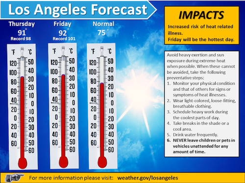
National Weather Sevice says we'll be on fire watch from late Tuesday night through Thursday or possibly Friday.
High temperatures (currently predicted at 92 degrees on Friday), low humidity, and winds mean increased risk of fire, especially in the mountain areas.
Full Weather Service outlook after the jump.
- Fire Danger - There will be a heightened fire danger due to gusty northeast Santa Ana winds starting late Tuesday night followed by the combination of hot temperatures and widespread single digit relative humidity Wednesday and Thursday, and possibly on Friday. Wind gusts of 45-55 mph will develop in the mountains with 35-45 mph speeds over the adjacent valleys before daybreak Wednesday. A marine layer will likely keep the winds at bay near the coast on Wednesday. Winds will pick up again Wednesday evening into Thursday morning including for the coastal areas. Fuel moisture will rapidly decrease during this event and is already 3 months ahead of schedule and similar to conditions normally seen during the month of August. The fire weather watch may need to be extended into Friday as hot and dry conditions will continue, but wind speeds will be considerably weaker. A return to onshore or westerly winds will develop by Friday afternoon generating additional winds during a period of very low relative humidity. Cooler temperatures and increasing humidity is expected on Saturday.
- Hot Temperatures - Unusually hot temperatures for this time of the year are expected for all areas on Thursday and Friday. Highs are expected to reach into the 90s for the majority of inland and coastal valleys with 100 degrees possible in a few locations, especially on Friday. Temperatures this warm will be 15-20 degrees above normal values for early May. In addition, a few record high temperatures will be possible. People not accustomed to hot weather so early in the year may be more susceptible to heat-related stress and/or hyperthermia.
SYNOPSIS
High pressure will build over the Great Basin this week strengthening the offshore winds across southern California starting late Tuesday night. Dry and hot weather will be experienced across the valleys and many coastal areas due to compressional heating as air flows over the mountains and sinks (warms) on it's way to the coastal beaches Wednesday through Friday. This Santa Ana will bring the highest threat of rapid fire spread and the hottest temperatures of the season to southern California Wednesday through Thursday, and possibly into Friday.
FORECAST CONFIDENCE
High confidence in the fire danger and hot weather potential from Wednesday through Friday. Moderate confidence in the wind speeds expected with this event.


